
The West Valley Fault in the Philippines is a 100-kilometer-long geological fissure that runs from Angat, Bulacan, in the north to Calamba, Laguna, in the south. It is a significant part of the Philippine Fault System and can produce large-magnitude earthquakes every 400 years on average. The fault runs through densely populated areas, including parts of Metro Manila, posing a significant seismic danger to the region.
Table of Contents
Characteristics of West Valley Fault
Location
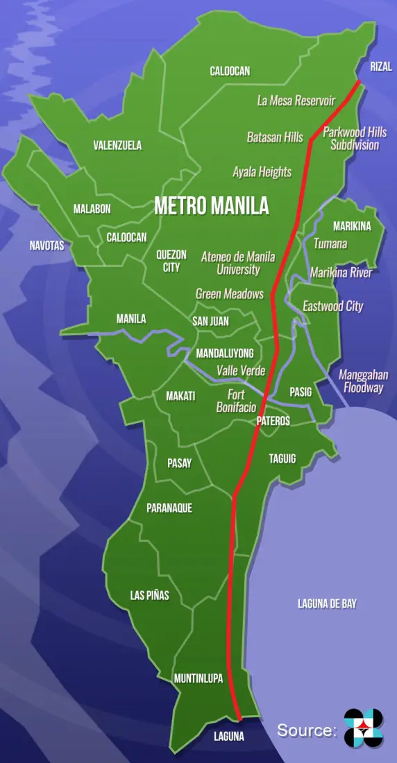
West Valley Fault starts near Angat, Bulacan, in the north. It extends through parts of the provinces of Rizal, Cavite, and Laguna before terminating near Calamba, Laguna, in the south. The fault passes through several cities and municipalities in the Greater Metro Manila Area, including Quezon City, Marikina, Pasig, Taguig, Muntinlupa, and San Pedro.
Earthquake frequency
The West Valley Fault has already caused multiple large-magnitude earthquakes, with an estimated recurrence span of 400 years. The most recent large quake connected with the fault occurred in 1658, and its magnitude was assessed to be 7.5 to 7.9.
Other significant earthquakes linked to the fault have occurred in 1645, 1771, and 1880. While these occurrences happened before to the introduction of modern seismological sensors, researchers have used historical records, geological evidence, and other data sources to estimate the size and location of these earthquakes.
Magnitude of major earthquakes in the past
The West Valley Fault has produced several large-magnitude earthquakes, significantly impacting the region.
- The 1658 earthquake, estimated to have a magnitude of 7.5 to 7.9, was one of the most destructive earthquakes in Philippine history. It caused widespread damage to structures and infrastructure, triggered landslides and liquefaction, and resulted in significant loss of life.
- The 1771 earthquake, estimated to have a magnitude of 6.5 to 6.8, also caused significant damage and loss of life. It triggered a tsunami that affected coastal areas and caused extensive flooding.
- The 1880 earthquake, estimated to be 6.3 to 6.5, caused significant damage to buildings and infrastructure in Manila and other areas. It also triggered landslides and caused liquefaction in certain areas.
While these events occurred before the development of modern building codes and earthquake-resistant design practices, they remind us of the potential impact of a large-magnitude earthquake along the West Valley Fault. Given the region’s high population density and development, a future earthquake along the fault could result in significant damage, loss of life, and economic disruption.
Geological features
The West Valley Fault is a strike-slip fault, which implies that the two sides of the fault move horizontally past one other. The fault is part of the Philippine Fault System, a vast network of faults that spans the country. The West Valley Fault, one of the main components of this system, can create large-magnitude earthquakes due to the accumulated strain between the two sides of the fault.
Geologically, the West Valley Fault is defined by a zone of compressed and fractured rocks known as a fault zone, which can range in width from several meters to several kilometers. The fault zone comprises deformed and fractured minerals such as sandstone, shale, and volcanic rocks.
In addition to the fault zone, the West Valley Fault exhibits tension fissures, thin fractures that form perpendicular to the fault and can indicate the direction of movement. The fault may also display signs of past earthquakes, such as surface ruptures, visible breaches in the ground where the two sides of the fault have moved past one another during an earthquake. These features can provide valuable information to researchers investigating the fault and assessing its seismic hazard.
West Valley Fault map
Effects of a West Valley Fault earthquake
An earthquake along the West Valley Fault could have significant effects on the region, including:
Damage to buildings and infrastructure: An earthquake along the West Valley Fault could cause significant damage to buildings and infrastructure, especially those not designed to withstand seismic activity. This could include collapsed buildings, damaged bridges, and roads, and disrupted utilities such as water and power.
Risk of landslides and liquefaction: The movement along the fault could trigger landslides and cause liquefaction in certain areas. Liquefaction occurs when loose, saturated soil loses strength and stiffness during shaking, causing it to behave like a liquid. This could damage buildings and infrastructure built on top of these soils, as well as an increased risk of ground failure.
Potential for loss of life and injuries: A large-magnitude earthquake along the West Valley Fault could result in significant loss of life and injuries, especially if buildings and infrastructure are not designed to withstand seismic activity. The dense population and development in the region could exacerbate the potential for harm.
Economic impact on the region: An earthquake along the West Valley Fault could significantly impact the region. Damage to buildings and infrastructure could result in billions of pesos in repair and reconstruction costs. Additionally, disrupting economic activity could result in lost income and employment opportunities.
Preparation and response
Preparation and response to a West Valley Fault earthquake should be a collaborative effort between individuals, communities, and government agencies.
- Awareness and education: Individuals and communities should be taught how to prepare for and respond to earthquakes. This can involve knowing the location of the nearest evacuation center, having a prepared emergency plan, and having an emergency supplies kit on hand.
- Building code and infrastructure upgrades: The government should enforce and update building codes to guarantee that structures and infrastructure are constructed to withstand seismic activity. Strengthening existing structures and adapting older buildings to meet modern earthquake-resistant design standards are examples of this.
- Early warning systems: The government should invest in early warning systems to warn of a potential earthquake. This can give individuals and communities valuable time to escape or take other precautions.
- Emergency response planning: Government entities should have an emergency response plan, including evacuation routes, medical response teams, and search and rescue teams. This strategy should be evaluated and revised regularly to reflect changing situations.
- Community participation: Communities should actively participate in earthquake preparation and response initiatives. This includes participating in drills and exercises, volunteering for local emergency response teams, and assisting in identifying potential risks in the community.
- Post-earthquake recovery: After an earthquake, the government and community should work together to assess the damage, provide medical care and support to those affected, and rebuild damaged infrastructure. It is important to prioritize the needs of the most vulnerable populations, such as the elderly, children, and those with disabilities.
Individuals, communities, and government organizations can assist in lessening the possible damage of a West Valley Fault earthquake by making proactive efforts to prepare for and respond to a prospective earthquake.
What are the other names of the West Valley Fault?
The West Valley Fault is also known as the Marikina Valley Fault System.
What are the areas in Quezon City within the West Valley fault?
Several areas in Quezon City are situated along the West Valley Fault. These include Barangays Bagong Pag-asa, Bahay Toro, and Pasong Tamo in District 2; Barangays Central, Old Capitol Site, and Krus na Ligas in District 4; and Barangays Loyola Heights, Escopa III, and Matandang Balara in District 5.
What are the areas in Marikina City within the West Valley fault?
Marikina City is one of the areas most affected by the West Valley Fault. The fault runs through several barangays (villages) in the city, including Barangays Concepcion Uno, Fortune, Industrial Valley, Jesus dela Peña, Malanday, Nangka, and Tumana.
What are the areas in Pasig City within the West Valley fault?
Several barangays in Pasig City are situated along the West Valley Fault. These include Barangays Bagong Ilog, Bagong Katipunan, Bambang, Buting, Kapasigan, Malinao, Maybunga, Oranbo, Palatiw, and San Antonio.
What are the areas in Taguig City within the West Valley fault?
In Taguig City, the areas affected by the West Valley Fault include Barangays Bagumbayan, Bambang, Calzada, Hagonoy, Ibayo-Tipas, Ligid-Tipas, Lower Bicutan, Napindan, Palingon, Sta. Ana, Tuktukan, and Upper Bicutan.
What are the areas in Muntinlupa City within the West Valley fault?
The West Valley Fault also runs through several barangays in Muntinlupa City, including Barangays Alabang, Bayanan, Cupang, Putatan, and Tunasan.
What are the areas in Laguna within the West Valley fault?
In Laguna Province, the West Valley Fault passes through several municipalities, including San Pedro, Binan, Sta. Rosa, Cabuyao, and Calamba.
What are nearby fault lines close to West Valley Fault?
Several other active fault systems in the Philippines are close to the West Valley Fault, including:
- East Valley Fault System
- Manila Trench
- Philippine Fault System
- Lubang Fault
- Verde Island Passage Fault System
These fault systems pose a significant threat to the Philippines, and residents need to be aware of their location and potential risks.